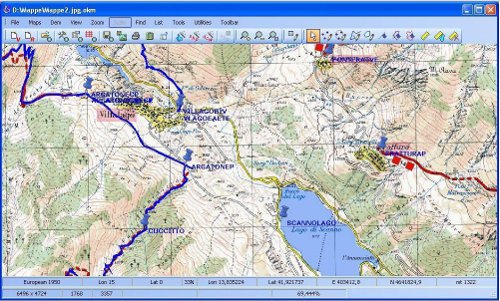
OkMap is a free GPS mapping software. It allows its user to calibrate cartographic projections with raster and vector maps. You can easily upload the digital maps to this software for tracking of location with the use of this software, OkMap. Off road, sailing, trekking and more are some of the outdoor activities which needs this free GPS mapping software. Thats not all you can easily import vectorial data to get height information from Dem data.
You can easily create drawing points of digital maps for e.g. polygon, multipoint etc with this great free GPS mapping software, OkMap. This free software has support for different images, vector data, Dem format, GPS data, maps and you can easily use this software to make conversions between various formats and coordinates. Vector and raster maps are used in background for navigation purposes by this free software for GPS navigation and this freeware can also manage all the waypoints very easily.
There are a lot of options like displaying of Google maps and Google earth in current location of the map and all the tracks and routes are formed in gpx format. Let us talk about some of the technical specifications of the free software, OkMap. You can upload the maps through Magellan and Garmin to Okmap and Nmea navigation is used for navigation purposes. You can also check out how to record your own voice in Garmin GPS.
You can automatically get Geo reference maps from Google maps to be used in this free GPS software, Okmap. All the details of your location like road paths, location etc can easily be determined with OkMap. Thats not all you can easily see your data in 3D Maps by exchanging it with Google Earth and you can use a calculator with this software for all your calculations.
So for all GPS navigation purposes you can use this free software, OkMap.
