Earthquake Scan is a free Windows 8 app, developed by David McSpadden. This app never ceases to intrigue and amaze, as it shows Earthquakes occurring in real time on Earth! The app interface showcases a World map, where the Earthquakes are shown in red dots. The redder the dot, the more intense is the Earthquake. The magnitude of Earthquakes is shown in the left (in Richter Scale Units).
This app is great for people who want to stay updated about intense Earthquakes, and it is also useful to people like travellers, as it allows them to know about the Earthquake-hot zones across the world, should they wish to avoid them.
This app is available from the Windows app store for free.
How to use this app?
Getting started with this app is as simple as 1-2-3. Simply download the app from the Windows Store, and the installed app should be visible on your Start Screen.
When you launch the app, you will be presented with a interface like the following screenshot.
As you can see in the above screenshot, towards the right, you can see the World Map with red dots showing the zones where Earthquakes have occurred recently. Towards the right, you can see the intensity of Earthquakes that have occurred recently (these are sorted according to the latest being at the top). Let us now take a closer look at the bar at the left of the screen.
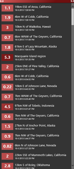
As you can see, I can see the most recent occurred Earthquake at the top. The list of Earthquakes is a scrollable list, and I can scroll down till the bottom to see more Earthquakes, that occurred less recently. The Earthquake Intensity is displayed in a red background, the intensity being measured in Richter Scale Units. The more intense the Earthquake is, the redder is the background where Earthquake intensity is mentioned for the particular area. At the time of writing this article, the last Earthquake occurred in the world only 20 minutes ago near California! Anyways, leaving that aside for now…
When you click on Any of the Earthquake from the left bar (shown above), the map on the right will automatically zoom in to that particular area. Have a glance at the below screenshot to see what happens when I select an Earthquake zone from the bar at the left.
Clicking on a particular Earthquake in the bar at the left side of the screen will automatically pan and zoom the map and take you to the location where the Earthquake had occurred. What’s more, you will be able to see even more detailed information about the Earthquake in a bar at the bottom of the map, after you select an earthquake from the bar at the left. Both of these things are illustrated in the screenshot above.
Apart from this, you can simply zoom inside the map by using the +/- buttons at the top-right, or if you are on a tablet/touch device, you can use pinch zoom to zoom inside the map and view Earthquakes. Do note that if you simply zoom inside to the map to a particular earthquake location without choosing the location from the left bar, you will NOT be able to see detailed information bar about the Earthquake at the bottom of the map.
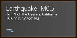
What’s more, this app offers live tiles! That’s right, it shows the most recent Earthquake information on the tile itself, without actually having to go inside the app. This comes in very handy when you quickly want to know where the last quake occurred in the world, without actually wanting to know all the complex details, thereby saving you the trouble of launching the application for doing the same. The live tile looks like the following: (see below screenshot)
You can see the Earthquake information in the above tile.
This is all that you need to know to start using the Earthquake Scan app.
On a serious note, do remember that Earthquakes are not a matter to be joked about, and please don’t use this app to have a laugh or be amused. This app is only meant for educational purposes, to stay updated, or for people who want to study the Tectonic activity of the Earth’s plates.
You can also check out other Windows 8 apps like tvBox, Quick Video player, 23Snaps.
To sum it all up…
Earthquake Scan is a great app in a manner that keeps you updated about the latest quakes, thereby warning tourists and calling attention of Relief NGO’s, as they can be updated about the places where high Earthquakes have occurred, thereby sensing the need for action. This app is also useful for researchers who are studying the Tectonic movement of the Earth’s plates and lastly, but not the least, the app is also useful for the common Joe who simply wants to stay updated.
The app is smooth, well designed, and the option of live tiles simply make it a truly wonderful app to have on your device.


